Rockport Cruising Guide
Excerpt
From Embassy Guides RI, MA, & NH
Also see an article published in Offshore Magazine
(Note: This guide was written several years ago,
and some of the information is outdated.)
Rock Solid
When you think of Rockport, think of rocks, lobsters, and
trees - for they are the foundation from which the town's history and character has grown
and molted. The first settlers harvested timber for the region's voracious shipbuilding
industry, but when all the prime cuts were consumed, their attention turned to the sea. The
well stocked fishing grounds nearby brought lots of boats, and in 1743, a timber wharf was
crafted to shield the vessels from the ravages of the ocean.
Around 1800, residents began to harvest the area's most obvious and
abundant natural resource - rock - and the wood pier was subsequently replaced with stone
barricades. It took 20 years to work out all the marketing quirks, but granite soon became
the cornerstone of the town's economy. For more than a century, quarriers pitted the north
of the cape, shipping blocks of bedrock all over the Atlantic Coast. Cape Ann's stone was
hewn into wharves, buildings, and streets for many of the eastern seaboard's thriving
cities and towns. In the 1920's, however, cement became the construction material of
choice and the rock market crashed. Luckily, Rockport was already evolving from its stone
age.
Artists had been gravitating to the area since the mid-1800's,
drawn by the colorful seaside scapes - both natural and fisherman-made. Like lobsters to a
fish head, the tourists soon followed, lured by all the aforementioned and the artists'
interpretations thereof. Over the years, the "starving artists" clawed ahead of
the seafood-harvesting folks, and galleries and shops now fill the stone wharves' fishing
shacks.
Today, Rockport is a funky combination: part artists colony, part
fishing port, and part shopping haven - all of it fodder for the tourists.
But look deeper, and you'll find friendly,
hardworking people who've somehow managed to preserve both the town's aesthetics and
integrity, while eking out a living by the sea.
Many visitors come to breathe in this colorful seaside village,
vicariously enjoying the "simple life" of the remaining fisher-/lobstermen.
Others are just happy to get a snapshot before spending a day in the shops.
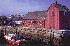
"Motif No. 1" has drawn more than its share of
attention.
� Embassy Guides
What To See and Do
Whether you're toting your
camera or carrying a canvas, your first stop should be the town pier (T
Wharf) in the center of the harbor. This is the spot to survey the
cornucopia of brightly painted lobster and other boats, and enjoy a
fine perspective of "Motif No. 1". Artist/tutor Lester
G. Hornby ordained this red, lobster buoy-draped building as the perfect
first subject for his striving students. The famed fishing shack apparently
exhibited an optimum balance of weathered color and form until a 1978
blizzard tried to enhance its look a bit too much, forcing the town to
completely rebuild the landmark. (Not to worry, with the way
nor'easters roll in around here, it shouldn't be long before it
regains its form.)
When in Rockport, it's hard
not to do as Rockport visitors do - shop. Bearskin Neck is the heart of the
gallery district, with myriad shops stretching out along Main and Beach
Streets. Since half the fun is finding the good ones, we'll let you do your
own exploring.
If you'd like to try your
hand at snatching traps, Captain Fred Nelson (978-546-9876) will be happy to
haul you aboard Dove for a lobstering trip through Thachers or
Sandy Bays.
The best and closest sand is
found just north of Bearskin Neck on Front Beach. The rockier Back Beach,
further to the north, has band concerts in the adjacent gazebo Sunday
evenings during the summer. For a complete billing of activities and
attractions, stop into the Rockport Chamber of Commerce (978-546-6575) at 3
Main Street.
If you grow weary in your
travels, hop aboard a Cape Ann Trolley (978-283-7916) for service throughout
the area.
Restaurants and
Provisions
There's one name you should
know before you order a highball at any local restaurant - Hannah Jumper. On
July 8, 1856, Miss Jumper and her band of not-so-merry women jumped the town's
too oft' visited grog shops. Hatchets in hand, they smashed every last keg and
bottle. To this day, Rockport remains a dry town, so it's a good idea to check
about a restaurant's BYOB policy. (Note: In 2005 Rockport voters approved the
sale of alcoholic beverages in local restaurants).
On Bearskin Neck, head to
Hannah's namesake restaurant, along the Harbor Deck (978-546-3600), for
sandwiches, salads, seafood, chowder, and one of the best vistas out of the
harbor. If you're looking for a more creative/romantic choice, try My Place By
The Sea (978-546-9667) at the end of the neck.
At the central T Wharf, Ellen's
Harborside Restaurant (978-546-2797) offers hickory smoked pit barbecue and
fresh seafood selections. This is good ol'-fashioned-cookin' with prices to
match. You'll find many other notable eateries in town - just follow your nose
and be sure to check the daily specials boards.
Head up to the Whistlestop Mall
on Railroad Avenue for groceries at the IGA, or basic boating needs at Smith's
hardware next door. The town's merchants don't want anyone caught short of
cash so you'll have no trouble finding a bank.
Navigation and
Anchorages
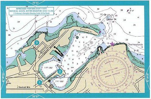
Use MAPTECH
electronic charts or NOAA paper charts 13279 (1:20,000), 13274 (1:40,000), and
13278 (1:80,000). Use tide tables for Portland, Maine. High tide at Rockport
is 4 minutes later, low tide is 2 minutes later. Use Portland, Maine
predictions for height at high or low water. Mean tidal range is 8.6 feet.
Rockport Harbor is protected by
two breakwaters: one extending east from Bearskin Neck, the other jutting
north from the Headlands. Even with this protection, the harbor is
exposed to strong easterly and northeasterly winds. Rockport is 11.5nm by boat
northeast of Gloucester Harbor, 19.1nm south of Gosport Harbor (Isles of
Shoals), and 7.7nm east of the entrance to Essex Bay.
Approaching from Portland,
the Isles of Shoals, and the north,
it's a straight shot to
flashing green gong "1 AHP" north of Halibut Point.
Then head for flashing green gong "3" [WP-270] at
the northwest end of the submerged breakwater. In the late 1800's, Congress
authorized construction of a 9,000-foot breakwater to enlarge and protect
Rockport's harbor. Six thousand feet of base and part of the superstructure
were laid before the money stopped, creating a million dollar navigational
hazard. Be sure to leave it to port.
From gong "3", head
south-southeast to red nun "4" at the harbor entrance, being sure to
stay east of Harbor Rock (covered 2 feet at mlw).The flashing red 4sec
"6", topped with a red dayboards, marks the breakwater at the
entrance.
If you happen to be coming from England or the east,
avoid Flat
Ground (.5nm long covered by 3 to 15 feet water) and Little
and Dry
salvages (awash and bare). The safest route is to pass well north of
both green bell "1", at Flat Ground and flashing green gong
"3", [WP-9815]
marking the submerged breakwater.
Coming from Gloucester and the southwest, head
northeast from flashing red 4sec whistle "2", south of Eastern
Point, to just east of Thacher Island (marked by 166 ft. flashing red
5sec horn). In good weather, it's impossible to miss the imposing pair of
124-foot gray granite towers.
CAUTION:
Be sure to avoid Londoner Shoal
(1 foot mlw) to the east-southeast. It's marked with only a black cylindrical
cage on a spindle - no light.
Swing north-northwest after
clearing Thacher Island and Londoner Shoal, and head for flashing red 4sec
bell "2" at Avery Ledge. Give Straitsmouth Island (low
and grassy), marked by 46-foot flashing green 4sec horn, a wide berth. At bell
"2" bear west-southwest for the harbor entrance. Pass green can
"3" marking a 9-foot rock, on either side, and mark flashing red
4sec "6", topped with dayboards, at the harbor entrance.There are
many enticing coves and beaches along your trip from Gloucester. They make for
great exploring in optimum weather and sea conditions - otherwise stay
offshore.
Rockport Harbor
is compact, filled with
boats and,appropriately, shaped like a lobster. The opening between the
breakwaters (the tail) is approximately 50yards wide with depths from 10 to 14
feet mlw. The inner harbor splits at the town wharf into north basin (right
claw: commercial boats) and south basin (left claw: mostly small sailboats).
For years, Rockport has been
bypassed by cruising boaters because it doesn't have a marina or boatyard.
Well, two new Harbormasters and a more transient-friendly attitude have done a
lot to improve the situation.While there aren't any official transient slips
or moorings, the Harbormasters are very accommodating. If you contact them
ahead of time (978-546-9589) or VHF 9, they'll do their best to arrange space
for you.
If there's no room inside, your
best bet is to anchor off the beach just to the north of Bearskin Neck. It
gets a little rough in high north-west winds, but like the cove just south of Sandy Bay Ledge,
it offers very good holding.
Granite Cove
is chock full of moored
boats.You can tie your dinghy at the town dock and walk to the end of Granite
Pier for a commanding view of Sandy Bay and Rockport. Pigeon
Cove to the north is used solely by commercial fishermen. The
LEGO-stacked, pink granite blocks aren't the remains of a giant kid's game;
they're real-life fortifications - when the nor'easters come rolling through,
it's WAR. If nothing else, take warning - if east or northeasterly winds are
forecast, get out. Head for Gloucester.
If you have any questions
or concerns, hail the Harbormasters.
They're always on call, ready to help.
Shoreside and Emergency
Services
Airport:
Logan International, Boston, MA
(617-561-1919)
Coast Guard: Gloucester, MA (978-283-0704)
or VHF 16
Harbormaster: (978-546-9589) or VHF 9 &
16
Hospital: Addison Gilbert, Gloucester
(978-283-4000)
Police, Fire, Ambulance: 911
Radio Telephone: Gloucester
Marine Operator: VHF 25
Taxi: Atlantic Taxi (978-546-7297)
Cape Ann Yellow
Cab (978-283-9393)
Tow Service: Sea Tow Newburyport, MA (978-462-8855) or
VHF 16
TowBoat/U.S.-Merrirnack River (800-391-4869) or VHF 16
Train: Rockport: MBTA (800-392-6100)
For information regarding
Embassy's beautiful cruising guides, contact:
Maptech Inc.
1 Riverside Drive
Andover, MA 01810
Tel 888-839-5551
Fax 978-933-3030
and please be sure to visit the
Maptech
Website for information on these guides, Maptech navigation software,
Chartkits and more.