Sandy Bay Breakwater
The following is an article which appeared in "New England
Magazine" in October, 1894.
Rockport, Mass.
THE BUILDING OF A BREAKWATER.
By Herman Babson.

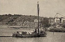
Tug "Cornelia", Rockport |
STRETCHING boldly into the Atlantic Ocean, forever defying the fury of the gale
and storm, the rocky shore of Cape Ann forms the northern promontory of Massachusetts Bay.
This promontory is in reality an island bounded on all sides but one by deep navigable water.
Toward the west it is separated from the mainland by a narrow canal, which is often entirely dry at low tide. Situated thus, and lying to the eastward of the
New England coast line above and below it, Cape Ann becomes a serious hindrance to coast navigation. |
| A glance at the map will at once show this. Starting
from Portsmouth, N. H., the shore runs in a southerly direction. Thence after Ipswich
is reached the coast suddenly bends toward the east, forming the cape. Thence it runs southwest
and west, for a distance of thirty-five miles, to Boston. |
Nor is the cape by virtue of its position alone a dangerous place to pass. Were there a good harbor here,
vessels, when caught by a storm in the vicinity of Cape Ann, would find it but little trouble to run in
for shelter. Gloucester harbor, at the southwestern end, offers but little practical service,
as vessels must needs first double the cape to reach it. Add to this the fact that a dangerous bar
extends across the entrance to Gloucester harbor, and we see that this place of refuge amounts to little more
than nothing.
It is estimated that more than seventy thousand vessels pass Cape Ann yearly.
It is a rare occurrence when, standing on Pigeon Hill, on the northeastern part of the cape, one cannot count
on a clear day from twenty-five to one hundred coasters, bound to or from the ports of Maine, New Hampshire or
the Provinces. Then, too, the constant going and coming of the Gloucester fishing craft causes the horizon
always to be dotted with white sails. Now and then a wreck occurs. The storm dashes a dismasted coaster upon
the foaming rocks; there is a crunching and grinding of timbers; and in a few hours the shore is strewn with
floating bits of wood or cargo. Perhaps a man or two is drowned. There is a brief mention made in the daily papers,
a passing interest in the event, a settlement of the insurance, - and the vessels sail to and fro as before.
Cape Ann has had its share of wrecks. Its pitiless rocks have picked up many an unfortunate craft which,
having lost its reckonings, suddenly sees before it the rolling breakers, hears the dull roar of the waves as they pound and
crash among the jagged bowlders, and then, borne on by the merciless rush of the tide, dashes itself to destruction.
Numerous life-saving stations at prominent places along the shore tell a silent but impressive story of the wrecks so frequent
on this rock-bound cape. During the last twenty years there have been no less than one hundred and forty-seven total wrecks,
and five hundred and sixty partial disasters.
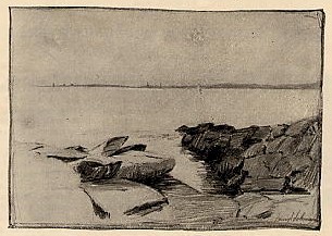
Sandy Bay from Andrews Point
These painful facts, together with the circumstances touched upon in regard to the geographical position of the cape,
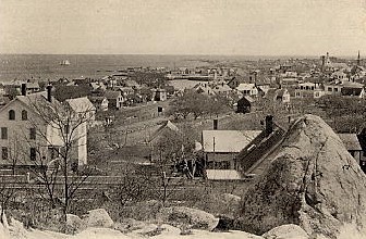
have caused the United States Government to undertake the construction of a breakwater at Rockport. Rockport is
a town of about
five thousand people, situated on the northeastern portion of the promontory. Prior to 1840 it was a part of Gloucester;
but at that date the people of Rockport disunited themselves from the older portion of the town, or "The Harbor" as it was commonly called,
and formed a separate community. It is a quiet, attractive little place, the northern portion of which, called Pigeon Cove,
is a well-known summer resort. Were it not for the stone business, which is carried on by several rich and busily worked quarries,
Rockport would be without any particular industry. Fishing, the common vocation of all the early settlers of Cape Ann,
has dwindled to a small scale, by reason of the business at Gloucester. Trawling in small 'longshore boats is the only branch
of this industry now carried on to any extent.
The town lies about an indentation of the cape known as Sandy Bay. The southern arm of this bay extends eastward one and a half miles
to Gap Head. Here the island of Straitsmouth, three eighths of a mile in length and but a few rods distant from the "Head", completes
the arm. The western arm extends northward two miles, to Andrews Point. Toward the east there is no protection whatever;
and during the easterly gales the waves roll in and strike against the shore with unchecked fury. Across this eastern open space the government
is now building a breakwater. When completed, it will rank with the already famous works at Cherbourg, France, and Plymouth, England.
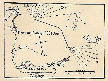
Showing location of proposed breakwater for a
Harbor of Refuge - Sandy Bay
Before entering upon any discussion of the breakwater itself and the work now going on, a few words upon the past history of the enterprise
will not be out of place. The present work is not the first undertaken at Rockport by the National Government. In 1836, a breakwater was begun
at what was known as Long Cove. Work was continued till 1840, when the appropriation was exhausted, with the structure still unfinished.
Although somewhat damaged in 1841, the work serves as a shelter from easterly gales. Besides this structure, several minor breakwaters or, more
properly speaking, piers, have been erected at private expense, near the various granite companies' quarries. At the village of Pigeon Cove, also,
a lofty mass of stone has been raised, behind which a few large vessels may find a place of safety. But these stone piers are all comparatively small,
and their advantages are utilized for the most part by those vessels connected with the granite business. The coasting craft receive no benefit whatever from them.
The practical advantages offered by these minor structures gave rise, as far back as 1830, to the idea that Rockport would be a most desirable place for a national harbor of refuge.
The deep water within the bay, the good anchoring ground and, above all, the lack of a large harbor between Portland and Boston, where vessels could find shelter during storms,
- these facts and others led to the hope that in time a breakwater would be built across the mouth of the bay. But this hope was entertained by only a few.
Like all great projects, it was met with objections and, more than all, with indifference. For years the matter received but little attention. Public
interest was not awake, and the opinion of experienced men was not sought. Finally, in 1879, 1880 and 1881, the interest in the project of a breakwater
seemed suddenly to spring up. Discussions became frequent, prominent men opened their ears, and public meetings were held. The hitherto quiet town realized
that it had something to work for; and the "Sandy Bay National Harbor of Refuge " became a common topic of conversation.
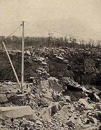
Rockport Granite Company's Quarry |
In March, 1881, a committee of twelve was appointed to bring the subject before the public. Numerous circulars were printed and sent throughout the country.
The attention of the press was called to the question, and the representatives in Congress were urged to further the undertaking as much as possible.
Success followed the efforts of the committee; and in 1882 the surveying was begun. Curious-looking poles and staffs were erected on prominent hills overlooking
the water, and for three years the engineers were busy marking out the course of the proposed breakwater.
The course, as laid out, provided for a V-shaped wall extending one mile north
west by west toward Andrews Point, where a northern passage is left two thousand feet wide. Southerly, the
breakwater extends a little less than three quarters of a mile to Avery's Ledge. Here is a southeastern entrance
measuring one thousand five hundred feet. The harbor thus enclosed is of more than one thousand six hundred acres, with a depth of sixty feet of water and excellent holding ground. |
November 12, 1885, is the time from which the first contract was dated. It extended to March 21, 1887, during which period one hundred and twenty-eight thousand tons
of stone were deposited. The second contract was from March 21, 1887, to June 23, 1888, when one hundred and fifteen thousand tons were sunk.
The third contract lasted from January 28, 1889, to June 28, 1890; under this appropriation one hundred and ten thousand tons were used.
The fourth contract extended from January 1, 1891, to August 31, 1892 ; by this, one hundred and eighty-five thousand tons were added to the amount.
The fifth contract began on October 14, 1892; and up to February 1, 1894, the breakwater had been enlarged by the sinking of one hundred and five thousand tons.
The stone thus far deposited amounts to about six hundred and fifty thousand tons. It is estimated that five million tons will be required to complete the breakwater.
The total appropriations to the present time reach the neighborhood of $750,000 ; and the cost per ton is about $1.15.
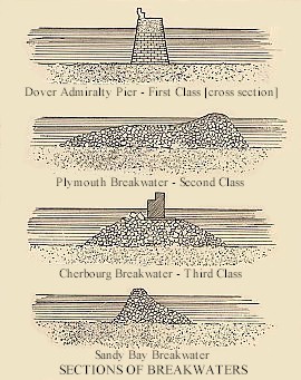
| For convenience of classification, breakwaters are divided according to their construction into three
kinds, vertical or nearly vertical, sloping and composite.
The first of these structures is generally built of carefully fitted blocks of granite, the walls extending perpendicularly or nearly so from the bottom to above high water.
This kind of breakwater is used to arrest the straight onward course of the waves, as well as to deflect them laterally. As an example of such, we may mention the Dover Admiralty Pier
in England. The second class, sloping, is very wide at the base, its walls extending obliquely to and above the surface. The part below low water is generally of loose rubble;
that above is composed of smooth stone or loose rocks as below. The action of this kind is, in the main,
similar to that of the first class. Such a breakwater is the work at Plymouth, England. |
 |
| The last form, that known as the
composite breakwater, combines the principles of the other two. It is constructed of loose rubble up to low water, upon
which sloping foundation a vertical wall is built. By this means the wave is caused both to break and to turn to one side.
The Cherbourg fortified breakwater is the best illustration of this class. To give a more definite idea of the three classes, diagrams are given,
with this article, of the breakwaters already mentioned. A section of the work now building at Rockport is also added, for the purpose of comparison. |
The "Arch", Rockport Granite
Company's Quarry |
The American breakwater comes under the second class, that represented by the Plymouth work; but, unlike the Plymouth, the top is constructed
of rubble. When the plans of the Rockport breakwater were being made, it was proposed to make a base of solid rock, with a level top forty feet wide at a depth of
twenty two feet below low water,
and to build a finished wall above the surface. But owing to observations made upon the action of the sea, it was decided later on to build a wall both the substructure and the superstructure of
which should be loose undressed stone. Thus the cost of the superstructure is greatly diminished, while it is believed that the
results of this departure from the usual mode of construction will prove entirely satisfactory. |
Although it is not the purpose of this article to enter into minute detail, a tabular comparison of the Rockport breakwater with those at Cherbourg and Plymouth will not be lacking in interest.
It will be seen that the one now building compares very favorably with its sisters. Indeed,
in several particulars it has the advantage in the comparison; and it is evident from an examination
of the table that the Sandy Bay Harbor of Refuge is destined to become as well known in the future as have the other two in the past.
| Name |
Kind of Work |
General Slope of
Outer Face |
Inner Face |
Top Above High
Water |
Width of Base |
Length |
Acres Enclosed |
Cost |
| From Bottom to Near Low Water |
Near Low Water |
Up to High Water |
Above High Water |
Above High Water |
Below Low Water |
| Plymouth |
Pitched slopes above high water, loose
rubble below. |
1 2/3 to 1 |
4 to 1 |
5 to 1 |
5 to 1 |
2 to 1 |
2 to 1 |
3 feet |
400 feet |
Nearly
1 mile |
1,182 |
$8,500,000 |
| Cherbourg |
Composite breakwater. Slopes of loose
rubble, with plumb wall above high water. |
2 to 1 |
7 to 1 |
7 to 1 |
|
7 1/2 to 1 |
1 to 1 |
12 1/2 feet |
300 feet |
Nearly
2 1/2 miles |
1,720 |
$12,500,000 |
| Sandy Bay |
Pitched slopes of loose rubble above and
below low water. |
2/3 to 1 |
2/3 to 1 |
1 to 1 |
1 to 1 |
1 3/7 to 1 |
1 to 1 |
9 feet |
175 to 300 feet according to
depth |
Nearly
1 3/4 miles |
1,664 |
$6,500,000 |
|
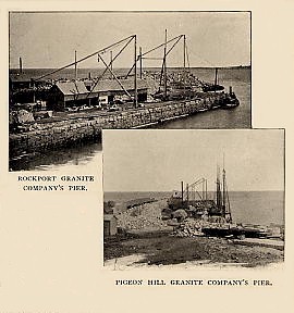
The work at Sandy Bay, as now carried on, is confined to two granite
companies,- the Rockport Granite Company and the Pigeon Hill Granite Company. The piers of these companies are but a short distance apart,
scarcely more than a quarter of a mile. The quarries from which the stone is taken lie to the west of the piers and are connected with them by railways, over which cars are drawn by horses.
Next to fishing, the industry of granite quarrying easily ranks second on Cape Ann. Around the entire cape numerous quarries are located, and thousands of tons are annually shipped to the great cities of
the East and West. The industry is continually growing. The supply of stone is inexhaustible; and the recent immigration to Cape Ann of numerous Swedes and Finns has caused the
working force of quarrymen to be increased by a class of men at once quiet and diligent. Twenty years ago the business was confined almost exclusively to the natives.
Now, groups of round-faced, light-haired Finlanders dressed in their red or blue flannel shirts, hammering away, and talking in their own tongue, while they seem strangely out of place on the old cape,
are nevertheless common sights.
| Of the two companies mentioned, the larger and the more interesting is the Rockport Granite Company. This company, besides owning extensive property at Rockport, has recently come into possession of the
valuable quarries and works on the western side of the cape, at Bay View. These latter quarries, however, furnish no stone for the construction of the breakwater, and our interest in them is only cursory.
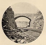
The Rockport quarries, belonging to this company, are among the largest on the cape. One of them, a great, deep hole near the main highway leading to Pigeon Cove, is fully a mile
in circumference. It varies in depth from fifty to one hundred and fifty feet. Rails are laid to every available place
in the quarry, whereon cars loaded with ton after ton of paving run down to the pier, where vessels wait to be loaded. Slow-moving ox-teams also wend their way in and out among the huge piles of cut granite;
and at noon or at evening the calm, patient beasts are loosed from their drags and, often without driver, stroll peacefully back to the stable. One of the interesting sights at this quarry is the great stone arch
over which the main road runs in its course round the cape. |
 |
 |
As you descend into this immense pit and walk among the workers busy with their hammer and drill, you catch sight at various places of large pieces of jagged, irregular masses of granite.
You are told that it is rubble - commonly called "grout" - to be used upon the breakwater. This rubble consists of pieces of granite otherwise condemned.
From their misshapen outlines you see at once that the stones can be put to no other use than that of being sunk into the sea for breakwater purposes ; and it is this rough and jagged granite alone that the government demands.
No round stone whatever can be used. Thus is a large amount of granite, which otherwise would be fit only for the stone-crusher, made to do a valuable service. |
The stone is conveyed from the piers to the breakwater by means of sailing sloops and scows. The method of loading these craft, while very simple, is full of interest.
Huge derricks run by machinery lift the stones from the car and carefully lower them into the hold or upon the deck. Sometimes when the smaller rubble is used, seven or eight pieces are transferred
from the car to the vessel at once. The loading of the sloops is slow and tedious. Care must be taken so to arrange the heavy masses along the deck that the vessels may list neither to right nor left.
As for the scows, the process of loading them is much more rapid. These latter craft are rectangular in shape, and of a decidedly clumsy appearance. They are decked only around the sides and ends.
The middle portion consists of two large holds, with patent bottoms, which by means of powerful levers are made to swing open when the occasion demands.
Into these holds the stones are lowered as rapidly as the derrick can perform its work. When about one hundred tons are thus deposited, the scows are ready to proceed to the breakwater.
The carrying capacity of the sloops is a little less.
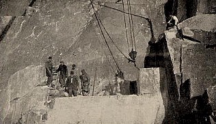
Quarrymen
The trip into the bay is the most interesting part of the work now carried on. The slow, lumbering sloops, having received their cargoes in the afternoon, are on their way to the breakwater early the next morning.
The scows leave at eight or nine o'clock, in tow of a tug. From the pier to the working ground it is one and three fourths miles ; and as the speed is very slow, about twenty-five minutes is required to cover the distance.
| It was a beautiful morning in March when, accompanied by an artist, the writer boarded the tug Cornelia, lying at the Rockport Granite Company's pier. The air was cool and exhilarating.
The waves sparkling beneath a bright sun were as inviting as though it were already midsummer. A few feet away a lighter was anchored, whereon a diver was preparing dynamite cartridges
for a submarine blast. To the rear of the tug a large three-masted schooner was moored, loading with paving. A few hundred feet distant lay the scow, her sides deep in the water.
The white blocks of granite in the hold rose above the surrounding deck, showing that she had received her cargo. By nine o'clock all was ready, and, taking the scow in tow, the tug steamed round the end of the pier and headed eastward for a distant
pile of rocks just visible from the wheel house. |
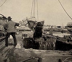
Loading a Scow |
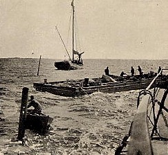
| As we neared the breakwater we saw the sloop busy at work lowering the stones overboard by means of a derrick attached to the mast.
Hardly had the Cornelia cast off from the scow, when the sloop hoisted her sail and started for home. She had been
at the breakwater for about three hours, and would not make another trip until the following day. |
A Lighter |
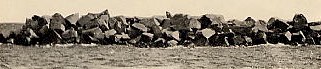
While the scow is getting into position to sink her cargo let us take a look at the breakwater. It is half tide. The stones rise from the water to the height of fourteen feet, and vary in weight from four to ten tons.
They lie closely wedged, their rough, sharp edges jutting out in all directions. Near the water's edge the granite is covered with a dark green slime. At each end the sea ripples and breaks over the top of the substructure just appearing above the
surface. Stretching away to both right and left, buoys raise themselves from water, marking the
course of the wall, which is still too far below to be visible. |
As we look upon this mass of roughly hewn rocks, with the waves washing among the numerous crevices, the seeming lack of any symmetry causes us for the moment to become prejudiced
in favor of the smooth, rounding surface of the Plymouth breakwater in England, or the solid and substantial work at Cherbourg.
But when we are told by the captain of the tug that this small bit of completed breakwater has successfully withstood the furious attacks of the winter gales, during which only a few stones were moved from their places,
we see that the lack of beauty is more than compensated for by the actual gain in the power to resist the mighty force of the waves. That the breakwater is built for service rather than for beauty is at once evident;
and that this rough, unfinished wall is the one best suited for the purpose, time will doubtless show. Of the superstructure six hundred feet is completed. The substructure has been laid for a distance of four thousand five hundred feet.
Scow Getting into Position to
Deposit Stone |
The scow meanwhile has been secured in its proper position. By means of cables run to adjacent buoys it is made
to float exactly over the place where the stone is to be dropped. Every thing is now ready. A man at one end
of the scow pulls a lever, which unlooses the bottom. A dull and heavy rumbling strikes the ear as the
granite blocks sink into the sea, while the scow, relieved of its hundred tons, springs buoyant upon the waves. The tug steams alongside, the ropes are cast off from the buoys, and
the journey homeward is begun.
To oversee this work upon the breakwater, and also to take account of the amount of stone deposited,
an officer is appointed, whose title is that of government inspector. His duties, while not especially arduous, seem to be rather monotonous. |
| No stone can be deposited during his absence.
Summer and winter alike this inspector goes out to the breakwater, recording the number of each vessel and the amount of stone taken on the trip.
Whether this inspector will have the pleasure of recording the last deposit of stone upon the Rockport breakwater is hard to say.
The progress is necessarily slow, owing to the small appropriations; and the most that can now be said is that the work is fairly begun.
That it will be finished is without doubt true. At present it is nothing more nor less than a menace to navigation; and government is in duty bound to make it of some service. Nevertheless, when we remember that it took seventy-four years to build the Cherbourg breakwater,
and twenty-nine years to complete the work at Plymouth, we have as yet no reason to be discouraged. |
| What will the breakwater do for Rockport? Will it, as some have thought, cause the quiet little town to become a commercial centre? Will the magnificent harbor attract transatlantic steamship companies,
and induce them to build piers into the blue waters of Sandy Bay? Will the rocky pastures of Cape Ann be made into streets, whereon large and costly buildings shall be erected?
Will this New England community become in time the metropolis of the region? |
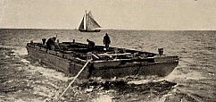
Going Home |
Probably not. But surely Rockport will become more and more a name dear to all who live upon the sea;
for here the sailor will find a haven, a haven where he may lie in safety and laugh at the fury of the storm.
A Section of the Breakwater
|
|
|